


le Pradet la Garonne-fort de la Gavaresse

bernir
User
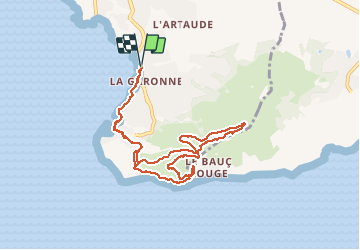

Length
9.8 km

Max alt
217 m

Uphill gradient
320 m
Km-Effort
14.1 km

Min alt
1 m

Downhill gradient
320 m
Boucle
Yes
Creation date :
2021-02-18 08:45:17.766
Updated on :
2021-02-18 19:10:00.061
5h39
Difficulty : Easy

FREE GPS app for hiking
 SityTrail
IGN / Geographical institutes
SityTrail Plus
The world is yours!
About
Trail Walking of 9.8 km to be discovered at Provence-Alpes-Côte d'Azur, Var, Le Pradet. This trail is proposed by bernir.
Photos


Positioning
Country:
France
Region :
Provence-Alpes-Côte d'Azur
Department/Province :
Var
Municipality :
Le Pradet
Location:
Unknown
Start:(Dec)
Start:(UTM)
257884 ; 4775423 (32T) N.
Comments